A silly post for today. Firstly, of what area of the world is the below a topographic map?
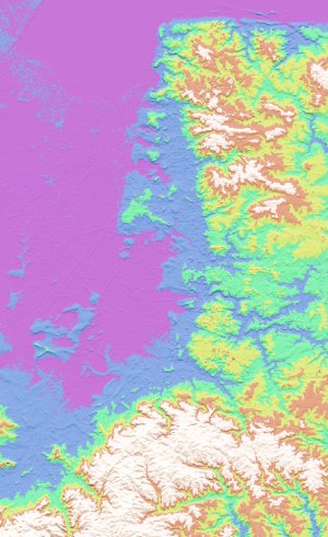
(Clues: the map is in the conventional orientation and is of a real place. You shouldn't need anything more to work it out than that. Answer tomorrow, or, at least, once enough amusing answers have accumulated.)
Secondly, since I try not to just post links to other stuff on here, I've... added a linklog for that purpose. RSS here.

Comments
Posted by Mat Bowles, Wednesday, 4 January 2006 22:22 (link):
I'd guess at Norway, but I'm not going to look at a map to find out. However, the linklog is the reason for the post: http://www.livejournal.com/users/lightfoot_links/
For us LJ obsessives resisting the lure of "real" RSS readers.
Posted by Cara de Sapo, Wednesday, 4 January 2006 22:31 (link):
New zealand!! the northern island
Posted by Alex, Wednesday, 4 January 2006 23:15 (link):
The east side of the Zuyder Zee.
Posted by Errol, Thursday, 5 January 2006 03:47 (link):
Why do you think so? Doesn't look like it to me, the square NW corner doesn't fit anywhere.
Cheers
Posted by Chris Applegate, Wednesday, 4 January 2006 23:46 (link):
North-west Scotland?
Posted by Alistair Turnbull, Thursday, 5 January 2006 03:06 (link):
I reckon these are the most plausible candidates, but I'm pretty sure they're all wrong: The wash; the Channel Islands; Portugal; The Hebrides.
I need a clue. Which contour is sea level? Presumably the answer to the title of your post is "because ... doesn't know the scale". So don't tell us that. :-)
Posted by Alistair Turnbull, Thursday, 5 January 2006 03:17 (link):
Oh, and my other guess is somewhere on Titan, because the latest link in your linklog is to maps of Saturn's moons, and Titan, though not listed there, is the only one with drainage channels on it. But it's not the Huygen's landing site and I don't think they've got topographic information for anywhere else so I reckon that's wrong too.
Posted by Alistair Turnbull, Thursday, 5 January 2006 04:07 (link):
One more guess.
Posted by Pete Stevens, Thursday, 5 January 2006 11:45 (link):
Without a scale it's very hard to guess. Here are some :
Somewhere entirely inland next to a plateau, Chile ?
A place in Japan that I have no idea how to type the characters for.
The surface of your last cup of coffee.
New Orleans.
Finland, it's got all the topography so it'll probably match even if the orginal map isn't from there.
Posted by Tom Steinberg, Thursday, 5 January 2006 12:59 (link):
It's obviously cambridge. Each colour is a 1 inch contour.
Posted by Francis Irving, Thursday, 5 January 2006 13:02 (link):
Assuming it is a trick question, I reckon purple is the land :)
Posted by Chris Lightfoot, Thursday, 5 January 2006 13:04 (link):
When I say it's in the conventional orientation, that includes the lighting of the relief.
Posted by Chris Williams, Thursday, 5 January 2006 14:04 (link):
Looks quite a lot like the Wash to me - I reckon I can make out Scolt Head right at the top. Having said that, it's probably Titan.
Posted by Chris Williams, Thursday, 5 January 2006 22:47 (link):
Nah, I've checked the map and I'm willing to bet you a tenner that it's the Wash, West Norfolk, and a chunk of points east and south. Not Titan. Or Phoebe, etc.
Posted by Iain Havard, Thursday, 5 January 2006 20:10 (link):
"conventional" = Las Vegas or New Orleans? But it does look very interesting so it could very well be Scotland.
Posted by Backword Dave, Thursday, 5 January 2006 22:05 (link):
I vote Scotland as well.
Post a new comment.
Comments copyright (c) contributors and available under a Creative Commons License. See also the comments policy.